Explore the database
The database currently contains details of 1002 pubs and other premises, 256 places and 209 people. There are also 329 photos and postcards, 80 pub signs, 672 newspaper articles, 253 maps and 104 documents. About 134 pubs are still open.Use the options below to search the database.
N.B. Some pubs do not appear on the maps as we do not have a definite location for them.
Quick search
Browse the database Advanced searchSomething not right? Got extra information? Please contact us and tell us more!
Details of place: Llanbadarn Fawr
County: Ceredigion
OS Grid Ref: SN599809 = 52.4081219758, -4.061016841
Type of place: Village
Notes: Llanbadarn Fawr was the name of a very large parish in north Ceredigion. It was spit into Townships and Hamlets of which Uwcha'n Dre and Issa'n Dre were two, and both became parishes in their own right by 1896. In 1934 these two were disbanded and a new parish, centered on the village of Llanbadarn Fawr was formed in 1934. In 1974 it became a Community Council.
Places associated with this place
part of: Llanbadarn Fawr (p)/
Show pubs
Pubs in this placeShow pubs
Beer House , Llanbadarn Fawr (p) (exact location uncertain)
Brynamlwg , Cefn Llan, Llanbadarn Fawr (p)
Dinas Hotel , Penparcau Road, Penparcau
Kings Arms , Llanbadarn Fawr (p) (exact location uncertain)
Plough , Llanbadarn Fawr
Six Bells , Llanbadarn Fawr (p)
Tafarn y Crug , Llanbadarn Fawr (p)
Talbot Inn , End of Lewis Terrace, Llanbadarn Fawr
Ty Mawr , Llanbadarn Fawr (p) (exact location uncertain)
Total: 9
Black Lion , Llanbadarn Fawr
Cors-fach Inn , Llanbadarn Fawr
Gogerddan Arms , Llanbadarn Fawr
Kings Head , Llanbadarn Fawr
Red Lion , Llanbadarn , Llanbadarn Fawr (exact location uncertain)
The Outback (Student Bar) , Llanbadarn Campus, Llanbadarn Fawr
Total: 6
Additional informationMap:
Black Lion and Gogerddan Arms, Llanbadarn Fawr, 6 inch map, 1904
Date: 1904
Map:
OS Map 1889
Date: 1889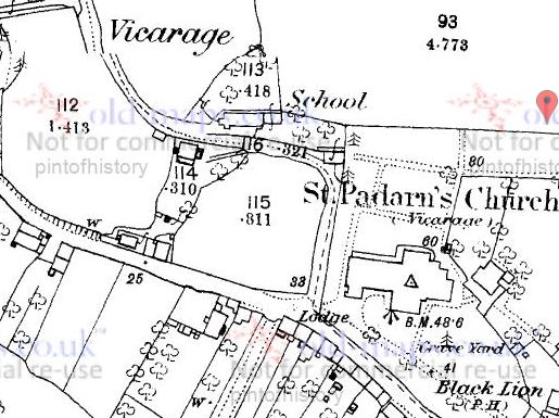
Postcard:
The square in Llanbadarn Fawr, Gogerddan Arms is the white building
Date: 1904 (approx)
Newspaper:
Cakes & Ale
Date: 1877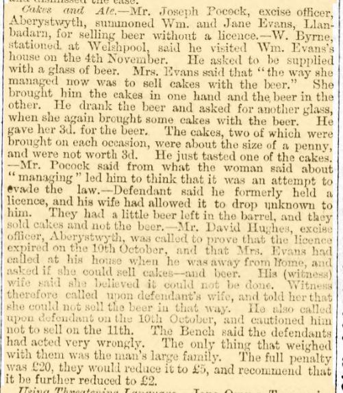
 = Inn
= Inn  = Beerhouse
  = Unlicenced
  = Other
  = Place